
With their historic economic power, everlasting natural beauty and surging recreation appeal, Dayton’s rivers are truly the crowning jewel of the Gem City. However, challenges along these great rivers, such as deteriorating trail infrastructure and dangerously steep levees, continue to restrict their potential. As a key partner in creating the Dayton Riverfront Plan (DRP), the Miami Conservancy District (MCD) continues its 108-year legacy of innovative flood protection, intentional conservation and energized watershed management.
Today, the City of Dayton, and other riverfront communities, are protected from dangerous high water and devastating flooding by the MCD’s integrated flood protection system. This unfailing flood protection enables the community to embrace the riverfront, building homes and businesses without fear of loss of property or lives. This also enables the development of riverfront access and recreation amenities all along the river corridor. Without this high level of protection, the Dayton Riverfront Plan would not be possible.
To make the river and trail safer and improve access and amenities, MCD has tackled several new projects in recent years that are prioritized in the Dayton Riverfront Plan (DRP). The map below identifies their locations.
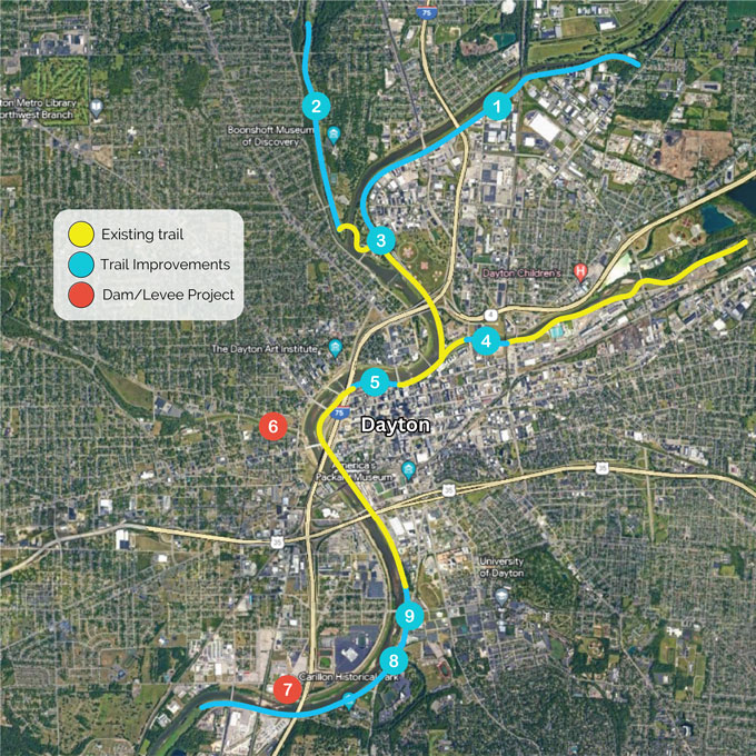
- Constructing a new bike trail in Old North Dayton located along the left bank from Island MetroPark to the Eintracht clubhouse and hand-carried boat launch. The first segment from Helena Street to Keowee Street in the DRP’s Culture Corridor is already under construction.
- Planning improvements to the Stillwater River Trail from the Gayle B. Price Bikeway Bridge to Siebenthaler Avenue, including swings, benches, trash cans, native prairie plants and cultural signage.
- Making five street-to-trail intersections along the Great Miami River Recreation Trail within the DRP’s Cultural Corridor safer with pedestrian-actuated flashing LED warning signs, ADA-compliant curb ramps, pavement striping highlighting the crosswalk and highly visible trail signage.
- Connecting the Mad River Trail, near Tech Town, to Webster Street in the Technology Corridor by widening the sidewalk along Webster Street and installing a new 12-foot-wide path, a small retaining wall, benches and trash cans.
- Improving the RiverWalk from Main Street to the I-75 bridge with upgraded lighting, swings, picnic tables, trash cans, way-funding signs and dog stations.
- Strengthening levees and improving access to Wolf Creek with more gradual slopes making it easier to access the river for recreation for West Dayton residents.
- Removing the Tait Station Dam south of Carillon Park on the Great Miami River improved the river’s ecosystem and eliminated a river hazard that was an impediment to paddling.
- Installing a new storybook trail featuring a children’s book about water along the Great Miami River Recreation Trail just north of Carillon Boulevard.
- Widening the Great Miami River Recreation Trail between East River Road and Stewart Street Bridge and add parking, lighting and other trail amenities.
To ensure the Dayton Riverfront stays protected from high water, MCD is also tackling a system-wide comprehensive capital improvement plan for the integrated flood protection system.
To learn more about MCD and its mission to protect, preserve and promote, visit MCDwater.org