
Dayton’s flood control system is the envy of the world. After the Great Flood of 1913, the Miami Conservancy District was formed with a system of five dry dams, ground-breaking engineering and hundreds of miles of levees which have kept the region safe from high water for over 100 years. These protective levees, while keeping us safe, also present challenges. Often as high as 20 feet and very steep, the levees create distinct separations between the city and the river. They often make it difficult to see the river and even more difficult to access it.
When developing the Dayton Riverfront Plan, we heard often that people wanted better access to our rivers. They wanted to be able to walk along them, hang out beside them, touch the water, and to get in—in a boat, to fish, to wade. This desire is so important that improving access to the rivers and strengthening connections to the surrounding neighborhoods became one of the Dayton Riverfront Plan’s six goals. The plan proposes laying back the levees at many spots along the rivers and building terraces, like what exists at RiverScape. The plan also recommends diversifying the plantings along the riverbanks and levees to create pollinator habitat, reduce animal waste and filter the water running into the rivers. One plan recommendation already completed: a River and Trail Access Plan proposing bikeways on both sides of the rivers and connecting the bikeways to the adjacent neighborhoods at least every half mile.
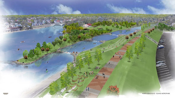
The Access Plan also puts forth new ways to get into the river on a kayak, canoe or standup paddleboard. Improvements are proposed for river put-ins at DeWeese and Triangle Parks, Island and Sunrise MetroParks, and south of Stewart Street on the Great Miami River. An ambitious vision, the plan proposes to add a peninsula to Island MetroPark that would allow the partial removal of the low dam there. Paddlers coming down the Great Miami or Stillwater rivers could paddle through the intimate and beautiful lagoon behind Island MetroPark and emerge in the shadow of downtown. In the future, every fan of Dayton’s waterways will have their pick of favorite ways to enjoy the rivers.